
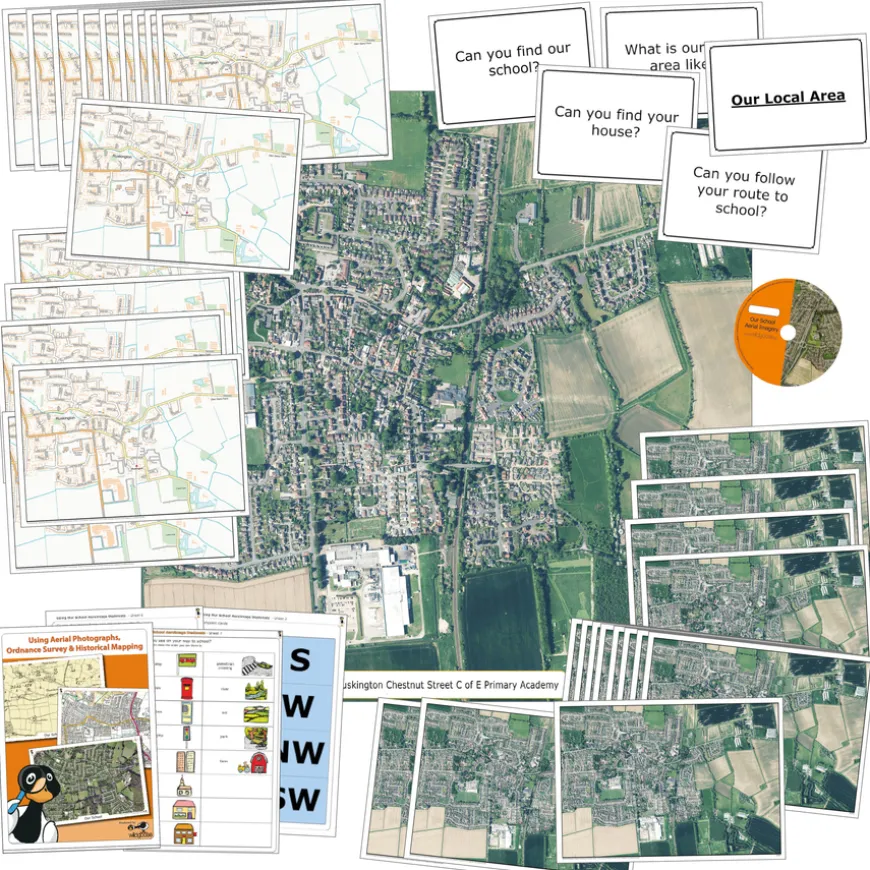
Aerial Photography School Map Classroom Pack
Original price was: £211.28.£99.48Current price is: £99.48.
Helping to Support Teaching and Learning
-
Comprehensive Pack
-
To ensure thorough geographical studies, a comprehensive class pack of OS maps and aerial photographs is available.
-
Includes Teachers’ Notes
-
Provides structured guidance and activity suggestions. Includes teachers’ notes and prompt cards of your local area.
-
Reusable Materials
-
For long-term classroom use, durability is key. Laminated maps and notes meet this need by being reusable.
-
Interactive Learning
-
Enhancing interactive learning experiences, the CD of maps and aerial photographs can be used on whiteboards.
-
Geographical Skills
-
Helps children use fieldwork to observe, measure, record, and present human and physical features. Supports Key Stage 2 geographical skills and fieldwork.
Aerial Photography School Map Classroom Pack
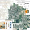
A collection of aerial photographs and current ordnance survey maps of your local school area.
Overview
-
The pack includes a CD with images of maps and aerial photographs for whiteboard use and 30 laminated prints.
-
Supporting Key Stage 2 and Key Stage 3 geography curriculum, it aids in using maps, atlases, and digital/computer mapping to locate countries and describe features studied. It includes 30 A4 Ordnance Survey Maps and 30 A4 Aerial Photographs centred on your school for comprehensive local area studies.
-
The pack helps interpret Ordnance Survey maps, uses grid references and scale, topographical and thematic mapping, and aerial and satellite photographs. It enhances interactive learning experiences in the classroom.
-
Please note this is a bespoke product, so it is not refundable or returnable if you change your mind.
Supports the National Curriculum
Geography, Key Stage 2, Geographical Skills & Fieldwork
Use fieldwork to observe, measure record and present the human and physical features in the local area using a range of methods, including sketch maps, plans and graphs, and digital technologies.
Geography, Key Stage 2, Geographical Skills & Fieldwork
Use maps, atlases, globes and digital/computer mapping to locate countries and describe features studied.
Geography, Key Stage 2, Geographical Skills & Fieldwork
Use the 8 points of a compass, 4- and 6-figure grid references, symbols and key (including the use of Ordnance Survey maps) to build their knowledge of the United Kingdom and the wider world.
Download free teaching materials
Product Information
Overview
-
1 x Aerial Image Playmat (100cm x 100cm), 30 x Laminated A4 aerial prints, 30 x Laminated A4 Ordnance Survey maps, 1 x CD of maps and aerial photographs for use on whiteboard, Laminated titles and key words for display, Teachers’ notes with activity suggestions, learning objectives and key vocabulary.
Product Includes
Be the first to review “Aerial Photography School Map Classroom Pack”
Related products
Exercise Books


Festivals & Celebrations

Early Years


Festivals & Celebrations

Book & Reading
Boxes & Containers


Pe & Outdoor



Art & Craft
Early Years

Dens & Play Equipment


Construction


Festivals & Celebrations
Babies & Toddlers


Festivals & Celebrations

Festivals & Celebrations
Reviews
There are no reviews yet.